Flexible all-in-one urban tree inventory and ecosystem services calculations tool
Documents
Acknowledgements
- Urban Ecos
- USDA National Institute of Food and Agriculture
- Calfire
- Azavea
- TreeKIT
- Christian Wolfsgruber
Urban street trees have myriad proven benefits for communities including providing shade, improving air quality, assisting with stormwater runoff, raising property values, decreasing utility bills, and enhancing the look and feel of communities. But effectively managing urban forests and calculating the ecosystem benefits of trees, while engaging the communities who benefit from them, can be a daunting task.
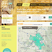
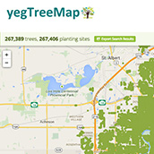
A unique collaborative platform for crowdsourced tree inventory, ecosystem services calculations, urban forestry analysis, and community engagement.
The system exists as an open source project or as a monthly subscription service).
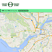
OpenTreeMap can be used in a single municipality or cover a broader geographic region with many communities or organizations.
Main Features
- Search for trees by species, location, or advanced filters such as diameter, date planted, or tree characteristics (flowering, native, etc.)
- Add trees individually or load tree datasets to the system
- Edit and add information about existing tree records including species name, location, height, plot size and type, conditions, actions needed, funding sources, data owner
- Upload tree photos
- Make your inventories public or private as you wish
- Customize all geographic and database search options, maps, stewardship activities
- Export tree lists as KML or CSV files
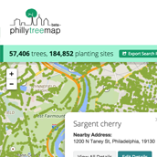
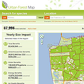
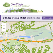
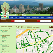
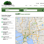
- Automatically calculate ecosystem services (greenhouse gas, water, energy, air quality) based on a tree’s species and diameter
- Monitor user accounts, comments, and system edits
- Optional integrated tree key to assist in identifying tree species
- Mobile and tablet versions available
Support
Have the base code but don’t know what to do with it? Interested in developing new features but don’t know how? We can help you implement your own urban forestry inventory application with OpenTreeMap. Our services include:
- Database development
- Software configuration and installation
- Graphic design
- Upload of tree datasets from local organizations
- Software customization
- Hosting